Berthoud Pass

Berthoud Pass is a scenic and historic mountain pass, located in the Rocky Mountains of Central Colorado. It connects the towns of Empire and Winter Park, offering incredible views, recreational opportunities, and a gateway to the high country. At an elevation of 11,307 feet, Berthoud Pass is a popular destination for outdoor enthusiasts and anyone looking to experience the beauty of Colorado’s mountains. This mountain pass is traversed by US Highway 40.

Berthoud Pass summit sign on the Continental Divide in Colorado

Seasonal Info

Open year-round with temporary closures for weather.

Berthoud Pass Stats

Alternate Routes – There are no quick alternate routes. Head north on HWY 9 from Silverthorne and then take HWY 40 east towards Hot Sulphur Springs and Granby.

The photo below was taken from an area high up on the Continental Divide near Colorado Mines Peak, while looking to the north/northeast of Berthoud Pass. The Indian Peaks can be seen in the distance, wrapping around to the right where the photo was taken from.

Map of the Continental Divide in Colorado segment with Berthoud Pass, Loveland Pass, Hoosier Pass, Fremont Pass, Tennessee Pass
Berthoud Pass aerial drone photo on Continental Divide in Colorado
Berthoud Pass highway with former ski area near summit

The photo above shows the western side of Berthoud Pass including (from right to left) the Stanley Headwall, No Name, and Russell Peak, with Highway 40 running below the terrain. That side is across from the Berthoud Pass summit parking lot, which is just out of the photo on the near side of the road. Much of the terrain on the right side of this picture was part of the Berthoud Pass ski area that was once located here.

The view from Winter Park Colorado looking toward Berthoud Pass
Looking towards the Continental Divide from a viewing platform at the Winter Park Ski Resort
hairpin turn on Berthoud Pass, Colorado
A switchback on the southern side of Berthoud Pass

Recreation on Berthoud Pass

Berthoud Pass is one of the most popular backcountry skiing areas in Colorado. There was once a ski area here, and the terrain is easily accessible by hiking from the summit parking lot. The ski area once rose above both sides of the highway at the top of the pass. These areas are still great for backcountry skiing during the winters.

There is no snowmobiling allowed on Berthoud Pass or anywhere nearby to the north. Snowmobiling is allowed on Jones Pass, located just on the southern side of Berthoud Pass. See the Clear Creek Ranger District for current updated info about snowmobiling regulations in that area.

Berthoud Pass FAQ

Yes, Berthoud Pass is generally open year-round, although temporary closures may occur due to severe weather or avalanches.

There are restrooms and a small visitor center located at the summit of Berthoud Pass. However, it’s a good idea to bring your own supplies, as facilities are limited.

This pass is similar to Loveland Pass in terms of difficulty and the driving environment. This means it can be a very difficult drive in bad weather. It is still not as dangerous or intimidating as Red Mountain Pass, but it is among the more dangerous of the paved highways over the Continental Divide in Colorado.

The closest towns to Berthoud Pass are Empire, CO, to the south, and Winter Park, CO, to the north.

Berthoud Pass during the summer

Hiking: Numerous hiking trails are accessible from Berthoud Pass, including trails to the summit of Colorado Mines Peak and Mount Flora. The Continental Divide Trail crosses the summit of the pass in the same spot as the highway.

Skiing and Snowboarding: Berthoud Pass has a rich history of skiing and snowboarding, and many locals continue to explore the slopes during the winter months. Don’t forget that backcountry skiing is dangerous, no matter how good you are.

Snowshoeing: When the snow falls, Berthoud Pass is a popular destination for snowshoeing, with miles of trails to explore. Try taking the Continental Divide Trail to the west, up the Nystrom Trail to Stanley Mountain.

Cycling: This pass is a fun highway for cycling, but beware of large motorhomes and lane crossers, especially around the hairpin turns.

Directions from Denver

How to get to Berthoud Pass from Denver? The drive from downtown Denver to Berthoud Pass takes about 1 hour, but the directions are easy to follow:

Did You Know?

Berthoud Pass was a final candidate for the Interstate 70 tunnel through the Continental Divide. Interstate 70 almost took a much different route through the mountains. One of the advocates for the Berthoud Pass route was Edwin C. Johnson, for whom the Eisenhower-Johnson Memorial Tunnel was eventually partially named after.

ascending Berthoud Pass during the winter by car

Berthoud Pass History

Berthoud Pass circa 1915-1930

Berthoud Pass was named after Edward L. Berthoud, a surveyor and civil engineer whose expedition discovered the pass in 1861.

May 9th, 1861 – Ed Berthoud leads an expedition to find a potential route for a wagon road from Golden City to the Salt Lake area. By May 22nd, he reported that he had found an excellent pass with an easy grade.1

Berthoud began work on the road sometime in 1862-63. The road was built piece by piece. By 1873, the road had been completed to the Big Bend, and a trail extended across the pass from there to Couzens’ ranch.

The first wagon was driven over the pass by Bill Updyke on Nov. 18, 1874.2

By 1875, the road was being run by William Cushman of Georgetown, likely still as a part of the Georgetown, Middle Park, and White River wagon road, which he had formed with L.D.C.Gaskill and others. Gaskill is also widely given great credit in building this road. The toll road was not profitable, and W.A Hamill acquired the toll road at a sheriff’s sale for $7,000.

William Byers, who owned the land that the Hot Sulphur Springs are on, and ran a stage coach line from Georgetown to the springs, recalled paying $7 per day to use the toll road.

The location of the road was shifted in 1892 by the Clear Creek County Commissioner (who also provided much of the above historical info) in order to lessen the grade.3

1918 – The Automobile Blue Book advises tourists to avoid Berthoud Pass. Grand County had only appropriated $1,400 for the annual maintenance of the pass, a section extending from the top of the pass to the Eagle County line. As a result, conditions were poor. The pass was also extremely narrow in spots.4

The modern highway was proposed in 1919 and completed in 1923. The road over Berthoud Pass is part of the historical Midland Trail, and hence, has been called the “Midland Trail Auto Road” among other names. The highway also became known as part of the Victory Highway and the Nation’s Memorial Road. Sometime during the 1930s, we began referring to the highway as US Highway 40.5

1933 – Gravel resurfacing is completed, but the US Bureau of Public Roads begins speaking with contractors about adding a paved surface over the gravel road.6

1934 – Bids were taken on May 28th, 1934, to pave Berthoud Pass. The job was to be for a full bituminous asphalt surface.7 A contract for oiling was reportedly awarded in August 1934.8 This was at a time when “oiling” was starting to refer to a method of hard surface paving. In the past, oiling had just been a thin surface that would keep down dust.

1938 – Paving of US HWY 40 over Berthoud Pass was completed. A ceremony was planned for July 2nd and 3rd.9

Berthoud Pass Inn at the top of Berthoud Pass, circa 1931
Berthoud Pass Summit House circa 1931

Early Winter Operations

Experimental rotary snowplows would be used to open this pass throughout the 1920s. The State Highway Commission built their own custom rotary snow plow in 1922, with intentions to test this on Berthoud Pass. It would eventually be tested in Douglas County instead. The first recorded mention of a rotary snow plow on Berthoud Pass was in May 1924, when the pass was opened at a record early date.

In February 1927, newspapers speculated that for the first time ever, Berthoud Pass would make it through the winter without closing. However, The Colorado Transcript reported on March 3rd, 1927, that the pass had been closed.9

$60,000 of new equipment was brought to Berthoud Pass for the winter of 1932-’33, and this would be the first winter that Berthoud Pass would stay open year-round.10

the old chairlift at the top of Berthoud Pass

The Berthoud Pass Ski Area was established in the 1930s, making it one of the first ski areas in Colorado. Although the ski area closed in 2001, the area where it once existed is still heavily used by backcountry skiers.

1. The Rocky Mountain News (Daily- Denver, CO), Volume 1, Number 228, May 22, 1861, p. 2. Colorado Historic Newspapers Collection. Coloado State Library.

2. Georgetown Courier, Number 2405, June 30, 1923, p. 1. Colorado Historic Newspapers Collection. Colorado State Library.

3. The Steamboat Pilot, July 11, 1923, p. 4. Colorado Historic Newspapers Collection. Colorado State Library.

4. The Kremmling News, Volume 15, Number 48, May 3, 1918, p. 4. Colorado Historic Newspapers Collection. Colorado State Library.

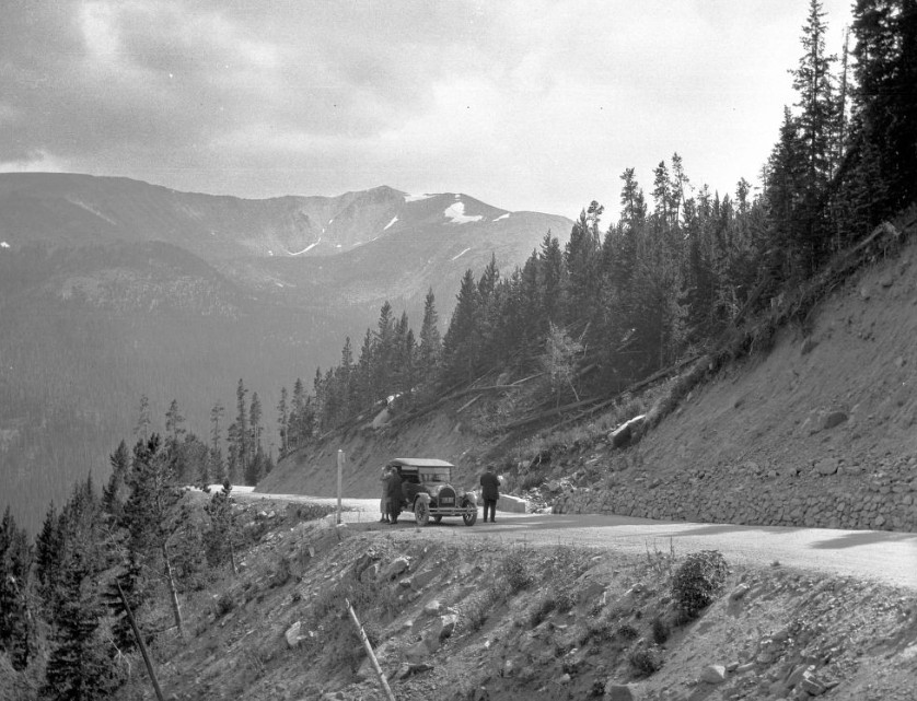
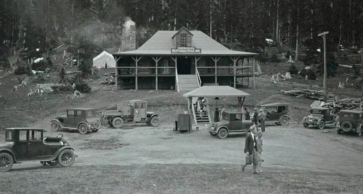
5. History of U.S. Highway 40 Over Berthoud Pass. 9.25.23. View.

6. The Steamboat Pilot, October 20, 1933, p. 2.

7. Craig Empire Courier, Volume 43, Number 46, May 16, 1934, p. 1. Colorado Historic Newspapers Collection. Colorado State Library.

8. The Steamboat Pilot, August 31, 1934, p. 3. Colorado Historic Newspapers Collection. Colorado State Library.

9. Craig Empire Courier, Volume 47, Number 50, February 9, 1938, p. 8. Colorado Historic Newspapers Collection. Colorado State Library.

10. The Colorado Transcript, Number 17, March 3, 1927, p. 8. Colorado Historic Newspapers Collection. Colorado State Library.

11. The Colorado Transcript, Number 10, January 5, 1933, p. 1. Colorado Historic Newspapers Collection. Colorado State Library.

Images Credits: Coloradotopia.com, Denver Public Library Special Collections [Z-8894][L-396], Library of Congress Carol M. Highsmith Archive, Wikimedia/xnatedawgx, Center for Land Use Interpretation, | More info